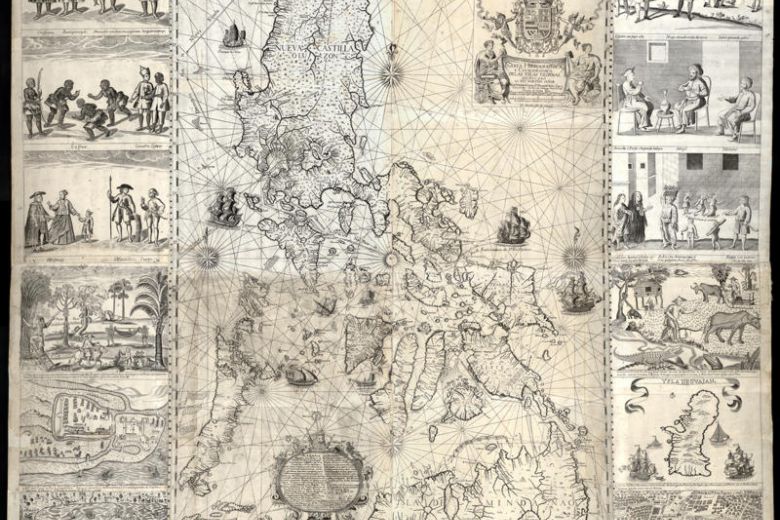
MANILA – A copy of a rare map that helped bolster the Philippines’ case against China in a dispute over the South China Sea was sold on Saturday (Sept 14) for 40 million pesos (S$1.06 million).
The price was nearly four times what a tech executive had paid for another copy at a Sotheby’s auction in London in 2014. Mr Mel Velarde, chief executive of local telco NOW, bought his copy for 12 million pesos.
The map was expected to fetch at least 18 million pesos.
Ms Lori Juvida, a gallery owner, tendered the winning bid. She later told The Straits Times it was “for a friend”. His identity has not been disclosed but he is believed to be a Chinese Filipino.
Mr Jaime Ponce de Leon, the director of Leon Gallery, where the auction was held said: “The strength of its price is its rarity and its historical significance… As a document of history, it is very important.”
The map, first published in 1734 by the Jesuit cartographer Pedro Murillo Velarde, was among 270 maps presented to a five-man arbitration tribunal to back the Philippines’ rights to parts of the South China Sea that China was also claiming.
It drew Scarborough Shoal – referred to back then as Panacot – as part of the country’s territories. The shoal lies just 358km west of the Philippines’ main Luzon island.
The tribunal in The Hague sided with the Philippines and struck down in 2016 China’s claim to the South China Sea.
It concluded that land features, not historic rights, determine maritime claims, and ruled that the “nine-dash line” encircling two million sq km of the South China Sea on modern Chinese maps is illegal.
It upheld the Philippines’ rights to over 200 nautical miles of “exclusive economic zone”, which included Scarborough.
China, however, has ignored the ruling.
Philippines President Rodrigo Duterte raised the case with China’s leader Xi Jinping when he visited China last month. But he was told China would not change its position on the matter.
His spokesman Salvador Panelo later said the two leaders “agreed to disagree”, and that Mr Duterte would no longer bring up the ruling with Mr Xi.
The 1734 map is by itself an important historical artefact. It was engraved by printer Nicolas de la Cruz Bagay on eight copper plates. The plates were captured by Britain when it occupied Manila from 1762 to 1764, and taken to England as war booty.
The University of Cambridge used the plates to print copies of the map before the plates were “rubbed down” and re-used to make other maps.
The copy auctioned on Saturday had belonged to the Duke of Northumberland.
Fewer than a dozen copies of the map exist today. Three are with the national libraries of Spain and France, and the US Library of Congress, while another three are in private collections in the Philippines.
The map has been described as the “mother of all Philippine maps”, as it was the first to accurately represent the Philippines and define its borders. It had the names of over 900 towns, cities and villages, and showed important rivers and waterways. Later maps would use it as reference.
What also made the 1734 map unique were 12 panels on both sides, drawn by artist Francisco Suarez, that depict everyday life in the Philippines in the 1700s.
The panels portray “sangleys”- as the Chinese who settled in the Philippines were called – as well as African slaves, Armenian and Persian merchants, and a Japanese samurai.
There are also depictions of cockfighting, and men and women going to church, playing the mandolin, dancing, cutting bamboo for scaffolds, steering a carabao, and pounding rice. There are images of forts and the walled city of Old Manila.
“It was the culmination of two centuries of map-making,” wrote curator Lisa Guerrero-Nakpil.

