 China never controlled the South
China Sea (West Philippine Sea) at any
time in history, as proven by the 1734
Murillo Velarde map.
According to Supreme Court Associate Justice Antonio Carpio, the map invalidates China’s Nine-Dashed Line and claims of
ownership of the South China Sea for over “2,000 years. Carpio delivered the keynote address at the opening of the 16th Philippine-Spanish Friendship Day Conference on Oct. 4 at the auditorium of the National Institute for Science and Mathematics Education Development (NISMED). The 2-day conference had the theme “Mapping Spaces and Identities in Spanish Colonial Philippines.”
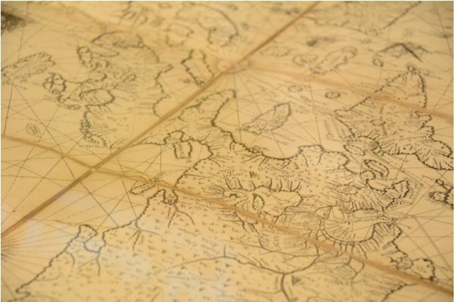
Official. Printed in Manila, the 1734 Murillo Velarde map by the Jesuit priest Pedro Murillo Velarde, was the Spanish government’s official map of its territories (both terrestrial and aquatic) in the Philippines. Called the mother of all Philippine maps and widely copied by Filipino and European cartographers, the map showed the maritime routes from Manila to Spain and Mexico and other Spanish territories to the New World, something very vital to the Galleon Trade, the first global trade by sea. According to the National Library of Spain, the map was drawn by Filipino Francisco Suarez and engraved by another Filipino, Nicolas dela Cruz Bagay. “The map is so detailed that when a magnifying glass is used, one can see all the towns and pueblos of the Philippines in 1734,” Carpio said. He was part of the team that argued before the Permanent Court of Arbitration (PCA) at The Hague in the Netherlands on the Philippines’ claim on the Sea. Included in the 1734 Murillo Velarde map are the Panacot shoal (Scarborough Shoal) and the Los Bajos de Paragua (Spratly Islands or Spratlys). It was one of the 270 ancient maps presented at the PCA hearings contesting China’s claim over the South China Sea (West Philippine Sea) that began in July 2015. Among the other maps presented were ancient maps of China throughout the Chinese dynasties, Philippine ancient maps and maps of Southeast Asia and European maps of Asia. China’s historical claim that it owned the South China Sea since 2,000 years ago (ed: roughly around the time of the Han Dynasty which began from 206 BC – 220AD) was refuted by Carpio and the Philippine team of experts. He said none of the ancient maps showed that China owned the contentious waters nor the Spratly islands and the Scarborough Shoal. The ancient Chinese maps’ southernmost territory was Hainan. “China in its earliest dynasty, from the Song and fast forward to their last dynasty, the Qing dynasty, and all their maps uniformly show that their southernmost territory is Hainan. So we presented this to the Tribunal. If you superimpose all the maps from the Song to the Qing dynasty, to over almost a thousand years, the southernmost territory of China was Hainan,” he said.
No historical claim. The Nine-Dashed Line is the demarcation line China used to claim the major part of the South China Sea. China maintains it owns any land or territory contained within the line. Among the territories claimed are the Spratlys and Scarborough shoal. The demarcation line was formerly 11 dashes. In his book “The South China Sea Dispute: Philippine Sovereign Rights and Jurisdiction in the West Philippine Sea,” Carpio explained that in December 1947, the “Kuomintang Government of China adopted the Nine-Dashed Line claim” that was embodied in a map “‘Location Map of the South Sea Islands’ released within China in February 1948, with 11 dashes forming a broken U-shaped line covering almost the entire South China Sea.” Carpio further explained the map indicates a claim to the islands and not the sea. In addition, there was no basis how the 11 dashes came about nor what its coordinates were. China claimed the islands enclosed in the 11 dashes, among them the Nansha Islands (Spratlys). Scarborough Shoal which is called Huangyan Island or its previous name, Min’zhu was not included. “China was silent on any claim to the surrounding waters,” Carpio said. In 1950, China under communist rule removed two dashes in the Gulf of Tonkin without any explanation. This was the beginning of the Nine-Dashed Line. On July 12, 2016, PCA tribunal ruled China had no evidence that historically it had exclusive control over the waters or resources of the South China Sea.
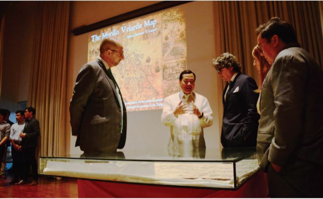
Carpio and Spanish Ambassador to the Philippines Jorge Moragas Sanchez (second and third from left) with Velarde (right) and other
international guests at the UP-NISMED Auditorium
History will correct them. Carpio aims to right this false claim of ownership, almost making it his personal crusade, reasoning that any person believing thus will know the truth because “History will correct them.” The associate justice conducts lectures here and abroad to let everybody know about the historical demarcation lines concerning the South China Sea and of the Scarborough Shoal and Spratlys as Philippine territories. Some members of the international community, even other Filipinos, are currently inclined to believe otherwise, particularly when Chinese Foreign Minister Wang Yi delivered a speech at the Center for Strategic and International Studies, the United States think tank in Washington, on Feb. 25, 2016. In his speech, he said the Treaty of Paris of 1898 proves the Scarborough Shoal and the Spratlys are not Philippine territories because they are all outside the Treaty Lines. The Treaty of Paris of 1898 was an agreement between Spain and the United States which included among others, the United States’ payment of US$20 million to Spain to cede the Philippines to them. In the Treaty, there were areas in the 1734 map of Murillo Velarde that Spain failed to cede to the United States, including Scarborough Shoal and the Spratlys. Nevertheless, Carpio argued the existence of the Treaty of Washington of 1900. “After signing the Treaty of Paris of 1898, the Americans came here and they discovered there were many islands outside the Treaty lines. So they went back to the Spaniards and asked the Spaniards to sign a Treaty clarifying the Treaty of Paris and that would include all these other islands outside of Treaty Lines. The Spaniards refused to sign,” Carpio said. He continued, “So the Americans told them, ‘On top of the US$20 million that we paid
you, we will pay you an additional US$100,000 to sign a second Treaty to make the clarification.’ The
Spaniards said, ‘Yes, we will sign!’” According to The Treaty of Washington of 1900, “Spain relinquishes to the United States all title and claim of title, which she may have had at the time of the conclusion of the Treaty of Peace of Paris, to any and all islands belonging to the Philippine Archipelago lying outside the lines described in Article III of that Treaty and particularly to the islands of Cagayan Sulu and Sibutu and their dependencies, and agrees that all such islands shall be comprehended in the cession of the Archipelago as fully as if they had been expressly included within those lines.” Therefore, Carpio said, with the Treaty of Washington of 1900 amending the Treaty of Paris of 1898, the Philippines can claim the Spratlys and Scarborough Shoal.
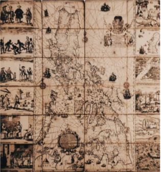
Cosmopolitan Manila. Not only did the Murillo Velarde map debunk China’s historical
narrative of South China Sea (West Philippine Sea) ownership, it also showed an 18th century Manila that was a rich cosmopolitan city, inhabited not only by the locals but foreigners from different parts of the globe and was a key city of the Galleon Trade. The associate justice said Father Pedro Murillo Velarde once wrote that if one stands on a bridge in Manila, one can see people from all parts of the globe, from Europe, Africa, Asia and North America. The Murillo Velarde map was originally engraved in eight copper plates and had on its sides a total 12 vignettes on the people and landscape of 18th century Philippines. The whole 1734 Murillo Velarde map is engraved on eight copper plates. The map itself is divided into four copper plates. It is between four other copper plates, two on each side. Each of these copper plates bear three vignettes. Eight vignettes depict people of varied ethnicities living in the country, and of flora and fauna found in the country. There is also a map of Samboagan (a city in Mindanao), a map of the port of Cavite — for the port was vital in building galleons at the time a map of the island of Guajan (Guam) and a map of Manila. The vignettes clearly depicted how important 18th century Philippines was in the Galleon Trade, and largely, to the Spanish empire.
The crucial role of the 1734 Murillo Velarde map in the Philippines’ case against China’s claim over the South China Sea (West Philippine Sea)is but one example of the importance of ancient maps in understanding history and present-day claims and situations. “Ancient maps are not merely decorative items far removed from present day reality. Ancient maps can come alive to help settle contentious present-day disputes among states. Individually, ancient maps contain errors and omissions because they do not have a satellite to get the correct configuration, but taken collectively over a period of time… ancient maps point to basic historical truth and expose greater than historical bias,” Carpio said.
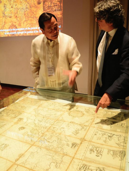
UPD’s own copy. At the conference, UP Diliman (UPD) received a facsimile of the mother of all Philippine maps. Its donor was information technology entrepreneur Mel Velarde, chair of the Asian Institute of Journalism and Communication. “I’m ere with a simple mission to give you a gift of the official replica of the 1734 Murillo Velarde map. My mission was to buy the map at an auction in London for you (the youth) because Justice Carpio wanted the youth to be able to see it and understand how blessed and rich our country is,” he said. Along with the official replica, Velarde brought the original map at the UPD conference for public viewing. He purchased the map for P12 million in an auction at London Sotheby’s in 2014. In 2017, Velarde donated the map to the National Museum. The original map once belonged to the Duke of Northumberland. It was one of a number of maps the University of Cambridge produced as fresh prints from the copper plates of the 1734 Murillo Velarde map. The Duke of Northumberland of the late 18th century bought a copy of the map and brought it to his residence at Alnwick Castle. The Castle has been used as a setting to many films and television series, and may be familiar to Potterheads for this was the interior and exterior of Hogwarts of “Harry Potter” films. There at Alnwick Castle,the map remained at its basement for over 200 years. In 2014, the current Duke of Northumberland announced the sale of family heirlooms that included the celebrated map. The official replica is currently at the UPD Department of istory and its public viewing is yet to be set.
By Mariamme D. Jadloc
Images by Leonardo A. Reyes
Source : https://upd.edu.ph/wp-content/uploads/2019/01/NEW-UPDATE-OCT-DEC2018.pdf